GeologicFeature Index Download service documentation
Version: 1.0
Editor: Matija Krivic (GeoZS), Sylvain Grellet (BRGM)
Scope
This TCS GIM GeologicFeature index download service documentation is here to help the end user understand the GeologicFeatureIndex model and use the view and download services.
The services
The TCS GIM GeologicFeatureIndex is an implementation of the GeologicFeatureIndex and contains discovery information for the pan-European surface geology at 1:1,000,000 scale. It is a transnational map provided by EGDI and harvested from INSPIRE-compliant national web feature services on GeologicUnit. There are two services made available to the users:
-
The Geological Feature View Service for visualising the content of the service.
-
The Geological Feature Download Service for data digestion and dereferencing.
Geological Feature View Service
The Geological Feature View Service (EGDI Geological Map 1:1,000,000): the surface geology entities are described as geological units forming a continuous map across Europe on the EPOS Data Portal. It is a Web Map Service (WMS) that follows the specifications of the Open Geospatial Consortium (OGC) standard WMS 1.3 (https://www.ogc.org/standard/wms/), which also is ISO 19128 standard (https://www.iso.org/standard/32546.html). As such, it can be used as part of the EPOS data portal but also interfaced directly.
The base address for the Geological Feature services is:
https://data.geoscience.earth/api/wmsGeologicUnit?
The capabilities document (GetCapabilities) for the WMS service is available at:
https://data.geoscience.earth/api/wmsGeologicUnit?service=WMS&version=1.3.0&request=GetCapabilities
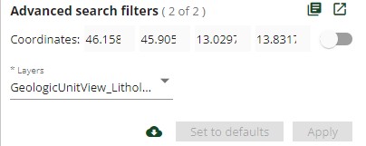
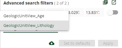
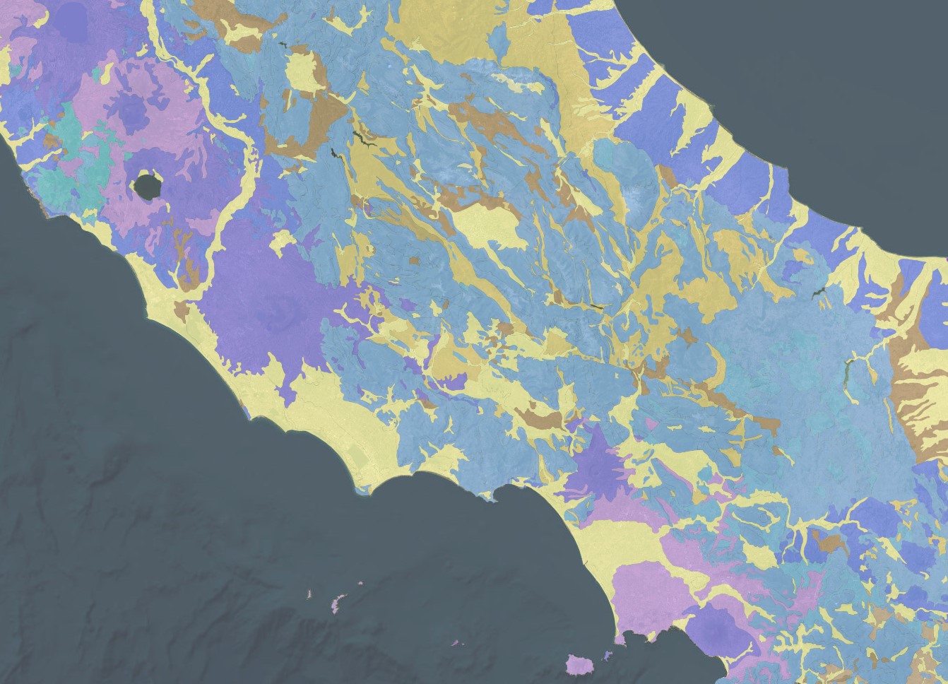
The Geological Feature View Service consists of two layers showing Representative Age or Representative Lithology. User can swithch between two layers by chosing one from the *Layers drop-down list in the Advanced search filters section.
Representative Age
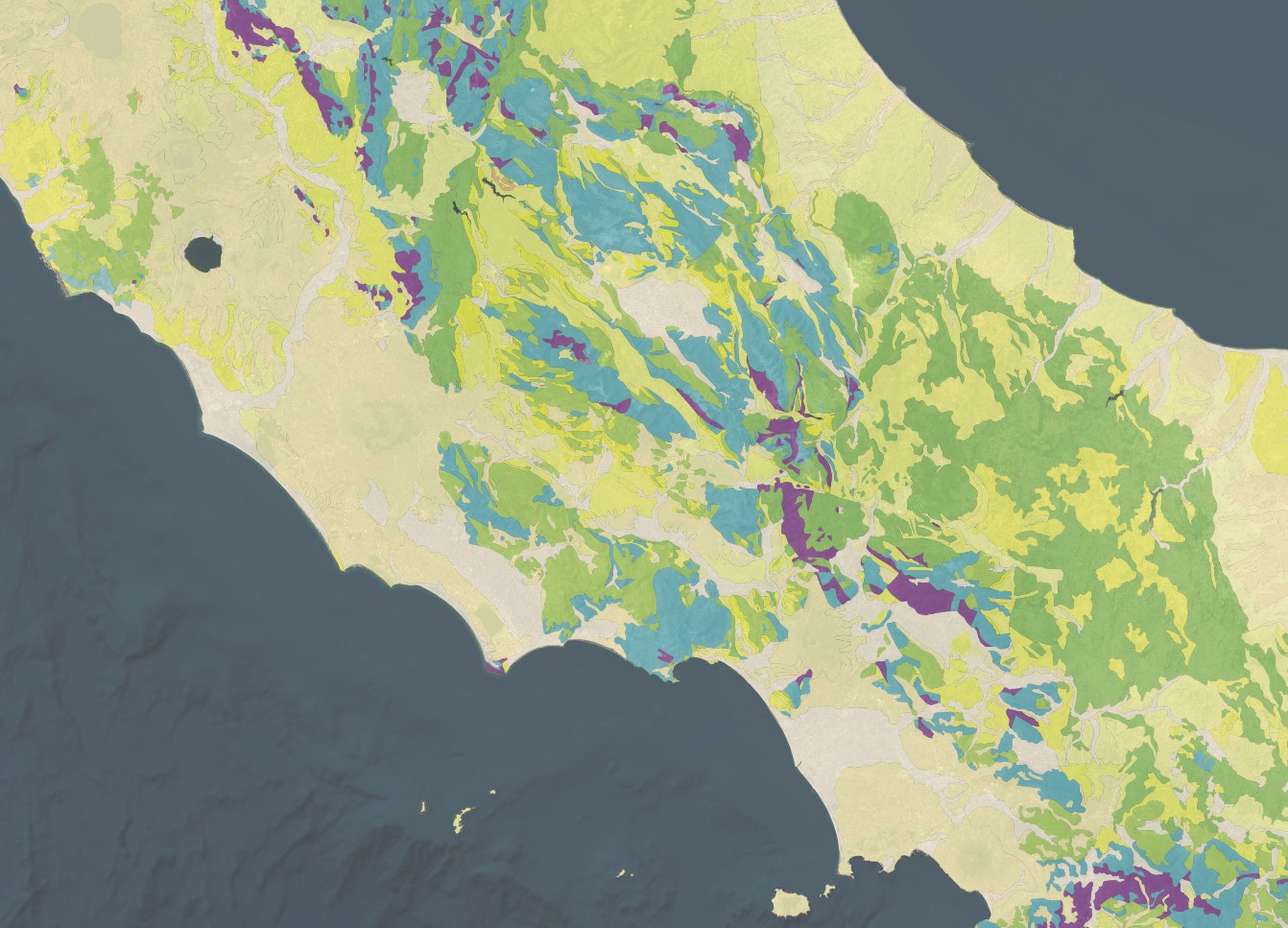
Representative Lithology
Query parameters of a straight Geological Feature WMS request include the coordinate reference system (crs), the image format (format), the image width and height, and the geographic bounding box (bbox), as in the example below:
https://data.geoscience.earth/api/wmsGeologicUnit?service=WMS&version=1.3.0&request=GetMap&layers=GeologicUnitView_Lithology&crs=EPSG:4326&format=image/jpeg&width=1536&height=660&bbox=40.45,10.85,42.97,16.41&STYLES=
In addition, attributes can be filtered for content by adding specific parameters (CQL filters) to the query. See section Searching data.
Geological Feature Download Service
The Geological Feature Download service: enables the user to search for GeologicUnit by matching a set of criteria such as location and other properties that are defined in the specification based on GeoSciML-Lite (e.g., lithology, age…), INSPIRE code lists are used. It is a Web Feature Service (WFS) that follows the specifications of the Open Geospatial Consortium (OGC) standard WFS 2.0.2 (https://www.ogc.org/standard/wfs/), which is related to ISO 19119 standard Geographic information - Services (https://www.iso.org/standard/59221.html). As such, it can be used as part of the EPOS data portal but also interfaced directly.
The base address for the Geological Feature Download services is:
https://data.geoscience.earth/api/wfsGeologicUnit?
The capabilities document (GetCapabilities) for the WFS service is available at:
https://data.geoscience.earth/api/wfsGeologicUnit?service=WFS&request=GetCapabilities
The schema of the service is available at:
https://data.geoscience.earth/def/epos-geosciml-lite
Query parameters of a straight Geological Feature WFS request include the output format (outputFormat) and the geographic bounding box (bbox), as in the example below. The maximum number of features is limited on the server side but can be also limited further by addinc count parameter to the request, to avoid returning millions of feature on not sufficiently restricted queries.
https://data.geoscience.earth/api/wfsGeologicUnit?service=WFS&request=GetFeature&typenames=epos-gsmlp:GeologicUnitView&version=2.0.2&outputFormat=json&bbox=37.6055,-2.0888,38.1914,-1.4699,urn:ogc:def:crs:EPSG::4326&srsName=urn:ogc:def:crs:EPSG::4326&count=50
In addition, attributes can be filtered for content by adding specific parameters (CQL filters) to the query. See section Searching data.
GeologicFeature Index model overview
The GeologicFeature Index model is the data model from which the Geological Feature View Service and Geological Feature Download Service services were developed. Built on the GeoSciML-Portrayal 4 Application Schema, FeatureType "GeologicUnitView" (http://geosciml.org/; a simplified view of a GeoSciML MappedFeature feature with key property values from an associated GeologicUnit).
GeologicUnitView is a simplified view of a GeoSciML MappedFeature feature with key property values from an associated GeologicUnit. The GeologicUnitView property values are summarised as labels (unconstrained character strings) or arbitrarily selected classifiers to be used for thematic mapping purposes. The latter are the properties suffixed with '_uri' and will contain URIs referring to controlled concepts in published vocabularies.

Attributes
identifier [CharacterString]:
Globally unique identifier:Primitive::CharacterString shall uniquely identifies a tuple within the dataset. Identifiers
shall be formatted as URI according to RFC 3986. This URI could be used to access more detailed, such as a GeoSciML Basic,
representation of the feature.
The identifier should have the same value as the corresponding GeoSciML MappedFeature identifier, if available.
geologicUnitType [GeologicUnitTypeCode]:
If present, the property geologicUnitType (Primitive::CharacterString) contains the type of GeologicUnit (as defined in GeoSciML).
rank [GeologicUnitRankCode]:
Multiplicity: ( [0..1], Allow duplicates: 0, Is ordered: False )
If present, the property rank:Primitive::CharacterString contain the rank of GeologicUnit (as defined by ISC. e.g.,
group, formation, member).
lithology [LithologyCode]:
Multiplicity: ( [0..1], Allow duplicates: 0, Is ordered: False )
If present, lithology contains a human readable description as Primitive::CharacterString of the GeologicUnit’s lithology,
possibly formatted with formal syntax. The description can be language-dependent.
targetCodeList: http://inspire.ec.europa.eu/codelist/LithologyValue
geologicHistory [CharacterString]:
Multiplicity: ( [0..1], Allow duplicates: 0, Is ordered: False )
If present, contains a human readable description in Primitive::CharacterString, possibly formatted with formal syntax, of
the age of the GeologicUnit (where age is a sequence of events and may include process and environment information). To
report an identifier from a controlled vocabulary, representativeAge_uri, representativeOlderAge_uri,
representativeYoungerAge_uri shall be used.
numericOlderAge [Measure]:
Multiplicity: ( [0..1], Allow duplicates: 0, Is ordered: False )
If present, the property numericOlderAge age is a numerical representation (Primitive::Number) of the unit’s older
age in million years (Ma).
numericYoungerAge [Measure]:
Multiplicity: ( [0..1], Allow duplicates: 0, Is ordered: False )
If present, the property numericYoungerAge is a numerical representation (Primitive::Number) of the unit’s younger
age in million years (Ma).
observationMethod [CharacterString]:
Multiplicity: ( [0..1], Allow duplicates: 0, Is ordered: False )
If present, the property observationMethod:Primitive::CharacterString is a metadata snippet indicating how the
spatial extent of the feature was determined. ObservationMethod is a convenience property that provides a simple
approach to observation metadata when data are reported using a feature view (as opposed to observation view).
positionalAccuracy [CharacterString]:
Multiplicity: ( [0..1], Allow duplicates: 0, Is ordered: False )
An estimate of the accuracy of the location of the borehole collar
location.
source [CharacterString]:
Multiplicity: ( [0..1], Allow duplicates: 0, Is ordered: False )
If present, the property source:Primitive::CharacterString is human readable text describing feature-specific details
and citations to source materials, and if available provides URLs to reference material and publications describing
the geologic feature. This could be a short text synopsis of key information that would also be in the metadata record
referenced by metadata_uri.
At this point the property gives information on a feature data provider (Country and organization. Options are: AT_GBA,
BE-GSB, CZ-CGS, DE-BGR, DK-GEUS, ES-IGME, FI-GTK, FR-BRGM, GB-BGS, GR-IGME, HU-MFGI, IR-GSI, IS-NI, IT-ISPRA, LU-SGL,
MT, NL-TNO, NO-NGU, PL-PGI, PT-LNEG, SE-SGU, SI-GeoZS, SK_SGUDS)
representativeAge_uri [RepresentativeAgeCode]:
The property representativeAge_uri:Primitive::CharacterString shall contain a URI referring to a controlled concept
specifying the most representative stratigraphic age interval for the GeologicUnit. This will be defined entirely at
the discretion of the data provider and may be a single event selected from the geologic feature’s geological history
or a value summarising the all or part of the feature’s history.
targetCodeList: http://inspire.ec.europa.eu/codelist/GeochronologicEraValue
representativeOlderAge_uri [RepresentativeOlderAgeCode]:
The property representativeOlderAge_uri:Primitive::CharacterString shall contain a URI referring to a controlled concept
specifying the most representative older value in a range of stratigraphic age intervals for the GeologicUnit. This will
be defined entirely at the discretion of the data provider and may be a single event selected from the geologic feature’s
geological history or a value summarising the all or part of the feature’s history.
representativeYoungerAge_uri [RepresentativeYoungerAgeCode]:
The property representativeYoungerAge_uri:Primitive::CharacterString shall contain a URI referring to a controlled concept
specifying the most representative younger value in a range of stratigraphic age intervals for the GeologicUnit. This will
be defined entirely at the discretion of the data provider and may be a single event selected from the geologic feature’s
geological history or a value summarising the all or part of the feature’s history.
specification_uri [CharacterString]:
If present, the property specification_uri:Primitive::CharacterString shall contain a URI referring the GeoSciML GeologicUnit
feature that describes the instance in detail.
metadata_uri [CharacterString]:
Multiplicity: ( [0..1], Allow duplicates: 0, Is ordered: False )
If present, the property metadata_uri:Primitive::CharacterString contains a URI referring to a metadata record describing
the provenance of data.
genericSymbolizer [CharacterString]:
Multiplicity: ( [0..1], Allow duplicates: 0, Is ordered: False )
If present, the property genericSymbolizer:CharacterString contains an identifier for a symbol from standard (locally or
community defined) symbolization scheme for portrayal.
shape [GM_Object]:
The property shape:GEO::GM_Object contains a geometry defining the extent of the feature of interest.
Searching data in the GeologicFeature index content
GeologicFeature data are searchable in the EPOS data portal by the latter’s native filter functions, or by querying the Geological Feature View Service or Geological Feature Download Service with CQL-Filters added to the WFS query (Note: bounding box and CQL-filters are mutually exclusive in WFS).
Attributes that can be filtered are
Attribute |
CQL property |
Vocabulary/format |
Example |
Identifier |
gml:identifier |
string |
gml:identifier='https://data.geoscience.earth/id/GeologicUnit/EGDI_1:1M/ES-IGME.ESP.IGME.GE.1000k_ONEGE11131.27382' |
Name |
gml:name |
string |
gml:name='ONEGE11131' |
Lithology |
lithology/@xlink:href |
object [gml:ReferenceType]: http://inspire.ec.europa.eu/codelist/LithologyValue |
"lithology/@xlink:href"='http://inspire.ec.europa.eu/codelist/LithologyValue/limestone' |
Lithology title |
lithology/@xlink:title |
string (Label from http://inspire.ec.europa.eu/codelist/LithologyValue) |
"lithology/@xlink:title"='limestone' |
Age |
representativeAge_uri/@xlink:href |
object [gml:ReferenceType]: http://inspire.ec.europa.eu/codelist/GeochronologicEraValue |
"lithology/@xlink:href"='http://inspire.ec.europa.eu/codelist/GeochronologicEraValue/paleozoic' |
Age title |
representativeAge_uri/@xlink:title |
string (Label from http://inspire.ec.europa.eu/codelist/GeochronologicEraValue) |
"lithology/@xlink:title"='paleozoic' |
Source |
source |
source='AT_GBA' |
|
Bounding box |
bbox |
geometric filter |
BBOX(shape,13,45,14,46) |
The full capabilities of the filter function are described in the GetCapabilities document. Use a URL encoding service for the filter content in case you have difficulties with whitespaces and special characters, e.g. https://www.url-encode-decode.com.
Example:
https://data.geoscience.earth/api/wfsGeologicUnit?service=WFS&request=GetFeature&CQL_FILTER=BBOX(shape,13,45,14,46)%20AND%20%22lithology/@xlink:title%22=%27limestone%27&typenames=epos-gsmlp:GeologicUnitView&version=2.0.2&outputFormat=json&srsName=urn:ogc:def:crs:EPSG::4326&count=5
Sources and more information
-
European Geological Data Infrastructure (EGDI) - https://www.europe-geology.eu/scientific-themes/basic-geology/
-
Urvois M, Grellet S, Lorenz H, Haener R, Loiselet C, Harrison M, Krivic M, Pedersen CB, Wiese MB, Baptie A, Nayembil M, Trench J, Marsh I, Cipolloni C, D’Ambrogi C, Congi MP. Integrating geological data in Europe to foster multidisciplinary research. Ann. Geophys. [Internet]. 2022Jul.12 [cited 2023Mar.29];65(3):DM319. Available from: https://www.annalsofgeophysics.eu/index.php/annals/article/view/8817